One thing forecasters do a lot of is looking at computer forecasts. There are a lot of them to look at. Some are generated by the NWS, some by other research agencies, some by other countries. If all of those forecasts have agreement with each other, the forecaster confidence increases. But we also realize that there are times that they all agree, but it turns out all of them were wrong. So agreement doesn't always mean a slam-dunk gonna-happen forecast, especially when you're looking several days into the future.
Over the past few days, many have heard rumors or whispers that a major snowstorm is on the way for the Inland NW. So let's take a look at what could potentially happen, and if the computers are still telling us to get prepared.
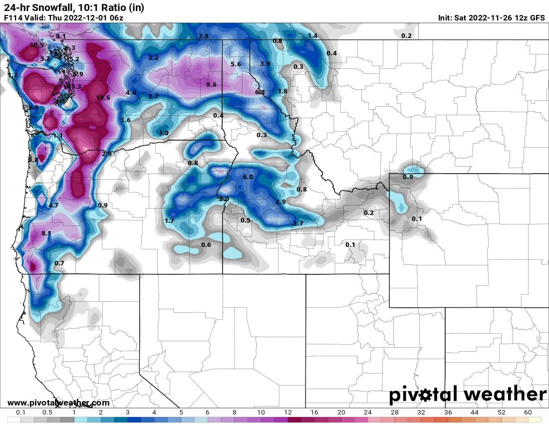
Saturday's GFS (U.S.) model looked rather snowy in eastern Washington for Wednesday. 9.6" for Spokane is a respectable storm.
The European model (ECMWF) had a similar look to it, albeit with a little less snow for Spokane (6.4") and a lot more for Sandpoint (14.3").
.png)
There are plenty of other computer forecast models we could look at it, all with varying snowfall amounts for Wednesday. But you get the idea. The majority of the forecasts pointed to a snowy midweek forecast.
The above graphics are based on a 10:1 Ratio of snow:liquid. What is that? We've all seen wet/heavy snow and dry/fluffy snow, and there's quite a bit of difference. The way the computers (and forecasters) work is that they first predict the amount of liquid precipitation that is expected to fall. Then based on a number of factors (e.g. air temperature), they use a ratio to convert the liquid into snowfall. A 10:1 ratio means that if you have 1" of liquid, you'll get 10" of snow. That's a fairly heavy snow, but it's close to the average. If temperatures aloft are cold, that ratio could be 15:1 or even higher. So that same 1" of liquid could produce 15" or more of dry fluffy snow.
Below is that same GFS forecast, accounting for the fact that the Wednesday snow event will be colder, and so the snow should be fluffier:
.png)
Now we're talking closer to a foot of snow for Spokane on Wednesday afternoon/evening, with still higher amounts to the north of the metro area. Those kinds of numbers will get people talking.
The computer models are run 2-4 times each day, and each forecast comes out a bit different. So what do the forecasts from todays computer runs say? Here's the latest GFS forecast:
.png)
.png)
So the GFS is still going for a significant snow storm for the Spokane metro on Wednesday. But here's the ECMWF forecast from Sunday:
.png)
What in the heck happened? 1.7" for Spokane? Why are we even writing a blog? The ECMWF forecast has drastically changed. And this happens a lot. One computer forecast looks snowy one day, and then the next day it looks much different. The ECMWF still gives some decent snow across the northern counties for Wednesday. But for the Spokane area, the ECMWF is now looking snowy for Friday instead of Wednesday.
So which computer forecast should we believe? At this point, one common approach is to take all of the various computer forecasts and average them together. And that's largely what the official NWS forecast is for now.

There is still a lot of uncertainty in this forecast. Confidence is higher for the northern counties, but much lower confidence for the I-90 counties. Spokane/CdA could see 8-12" on Wednesday, so it would be wise to plan accordingly. But if the European model forecasts are correct, this forecast will have to be revised considerably in the coming days.
No comments:
Post a Comment