Wednesday, November 13, 2013

So what comprises an accurate snowfall forecast?

So what comprises an accurate snowfall forecast?

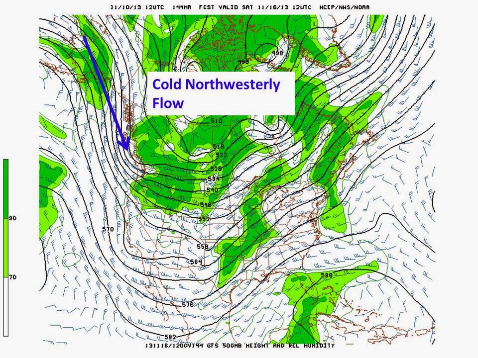
Confidence is growing that portions of the Inland Northwest are going to see a moderate snow event beginning Friday and ending sometime on Saturday. Temperatures will assuredly be sufficiently cold over the mountains and should likely be cool enough over some of the valleys. The weather pattern looks very consistent between model solutions. Looking at the spaghetti charts below, there is good consistency between different model perturbations with all runs showing a deep trough located over the northwest US by Friday afternoon. Recall, the closer the lines are to one another, the better the model agreement and thus the confidence in a model solution.  For a more thorough explanation of ensemble forecasting and spaghetti charts, please refer to our posts about a persistent ridge in October.

Spaghetti charts for Friday afternoon
If this pattern materializes as shown, there will likely be a good precipitation event focused over parts of the region. The question is where will the greatest threat occur.  Below are the latest forecast chances for receiving 4" and 8" or more of snow between 4am Friday and 4am Saturday. 

4" or greater snowfall chances 4am Friday 11/15- 4am Saturday 11/16

8" or greater snowfall chances 4am Friday- 4am Saturday
We are confident that the mid-level wind direction will be out of the west to southwest, which should focus the heaviest precipitation amounts near the Cascade Crest and over the Idaho Panhandle due to orographic ascent (think of the wind forcing the moisture over the mountains). There is also little doubt that temperatures over the mountains will cold enough to support snow.This confidence can be can be expressed utilizing a probablistic forecast which displays the chance of meeting or exceeding a certain weather parameter. Typical weather forecasts you read on our webpage or see on TV do not typically show these chances. Rather we produce what's termed a deterministic forecast. 

Deterministic forecasts show a specific value (or range of values) for any given location, whether it be a temperature, wind speed, or snowfall amount. The map below is what we are deterministically  forecasting (as of 1pm Wednesday) between Friday morning and Saturday afternoon. For Spokane, the latest deterministic forecast shows values ranging from 1-3", a far cry from the probabilistic forecasts seen above. 

Snowfall totals from Friday morning-Saturday afternoon---issued 1pm Wednesday
We do produce a widely used probabilistic forecast and that refers to the chance of seeing measurable precipitation (anything .01" or greater during the 12hr period). Here's what our written forecast says for this period for Spokane. Notice through the entire period we mention a chance of precipitation of 70% or greater. Nowhere though do we really mention specific snow amounts, rather we broadly characterize snowfall accumulations. 


So why the difference between the forecasts? Much of revolves around the terrain and the impact it can have on temperatures and precipitation amounts. Valley temperatures for this event could remain at or above freezing...at least through much of Friday and early Saturday across the Spokane Area, Palouse, and Lewiston area. Confidence is higher that temperatures will remain cold enough for snow over the valleys of northeast Washington and the Idaho Panhandle. Colder air will likely arrive later on Saturday. But temperatures and precipitation aren't the only factors that go into a snowfall forecast. There are issues to consider. Here's a list of parameters used for a snowfall forecast? 
  • QPF or precipitation amounts
  • Snow levels
  • ground temperatures
  • ratio of water to snow equivalent
  • time of day and expected road temperatures
So lets look at some of these parameters, like we do at our office this time of year and calculate a snowfall total for Spokane.

Precipitation forecast early Saturday morning
The image above is fairly straightforward. We are forecasting precipitation over most of the region aside from western portions of the Columbia Basin. The forecast for Spokane calls for 0.13" of precipitation with significantly heavier amounts expected to the north and east of Spokane, especially over the mountains. If temperatures were cold enough, it would all fall as snow, but we can't determine that just by looking at this parameter.  

So how about temperatures? Below is the forecast for early Saturday morning. Locations with temperatures below freezing are blue and purple. Locations above freezing are green and yellow. Notice most of the Columbia Basin is green, but locations such as Spokane show a forecast right around freezing. 

Temperatures for early Saturday morning
So can snow fall at these forecast temperatures? Absolutely, but not necessarily. There is more that factors into the equation. What are the temperatures above the ground and what would they support for snow levels?

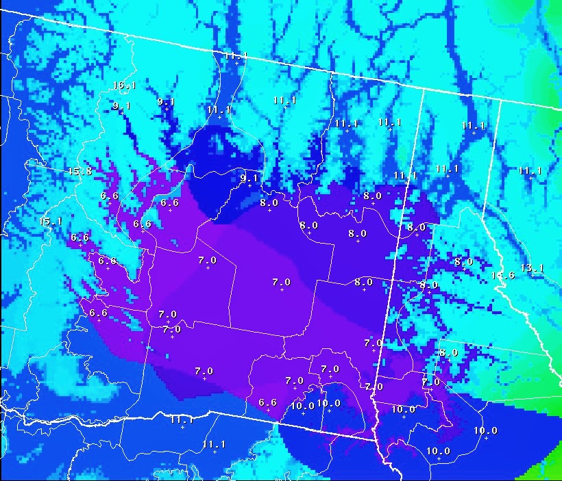
A snow level  is the elevation at which the precipitation will fall as all snow. Our forecast for Saturday morning calls for a snow level at 2300 feet. That means locations such as the Spokane Airport, South Hill and our office would be high enough for snow, while locations such as the Spokane Valley (at 2000' and lower) are more likely to see rain (provided the snow level forecast is accurate).

Snow level forecast for early Saturday morning in feet above sea level
So if most of what falls early Saturday morning is snow over the West Plains how easily will it accumulate? That depends on what the temperatures of the surface its falling on are. The fact that its falling early in the morning will negate the impact of daytime heating on the road surfaces or the ground. But if temperatures don't cool much overnight due to significant cloud cover that notion isn't as clear cut.  Clearing skies during the evening would lead to a much better chance of accumulating snows by morning. Timing a snow event during the shoulder seasons (before the cold of winter sets in or ends) is critical. A significant snow accumulation during the afternoon hours is much less likely than one during the late night or early morning hours given near freezing temperatures.

So the only other factor to consider is what will the ratio of snow to water be. Recall, we were forecasting about 0.13" of rain in Spokane. A crude rule of thumb is take that rainfall and multiply by 10 to come up with a snowfall total (1.3"). But really its not that easy, especially with complex temperatures and complex terrain. Across eastern Washington and north Idaho the typical snow:rain ratio is 13:1 or 13" of snow to every 1" of rainfall or liquid. But that also can be misleading since much depends on the temperatures. A cold air mass yields higher ratios than a warm one and that more or less explains our snow ratio graphic below. Other factors can come into play are how strong is the lifting in the atmosphere. Strong ascent leads to higher snow ratios. An unstable air mass can also lead to very high snow ratios (like we see in the spring with heavy snow showers and huge snowflakes or dendrites). 
Snow to water ratios for early Saturday morning

So we put all those pieces together and we come up with the following snowfall forecast for early Saturday morning. Light snow is forecast over the West Plains and South Hill, but less than 1" in expected with no accumulations in the Spokane Valley.
Snowfall forecast for early Saturday morning

Obviously there is a lot that goes into making a snowfall forecast. It's unquestionably one of the most difficult facets we forecast in the Inland Northwest. Even with a perfect forecast of the precipitation amount, the resultant snowfall can vary significantly from our prognostications. To add another layer of complexity, what would happen if the moisture from the system decided to remain bottled up near the Canadian border, rather than slowly sag south toward Oregon? Would that lead to a good forecast or would it present a huge forecast bust? We always hope for a perfect forecast, but there are so many variables at play, that fallibility potential can be very high, even after the onset of the event. 

Tuesday, November 12, 2013

Update on the Upcoming Pattern Change

After our last blog entry on Sunday about the potential for a weather pattern change, some of the computer forecast models wavered a bit in their forecast.  But they're back in agreement so confidence is increasing.  For those interested in why the computer forecasts change and how we use them, we'll address that topic in the 2nd half of today's blog.

The computers all agree on a Friday afternoon arrival for the storm.  The timing of the arrival will be crucial to the type of precipitation on Friday.  Temperatures Thursday night will likely cool to freezing or below.  But more importantly, temperatures aloft will also be cooling.  If the storm arrives late in the day, temperatures will likely warm into the upper 30s or lower 40s, and the precipitation will fall in the form of rain.  But if the storm starts by mid/late morning, our temperatures will likely be cold enough to keep the precipitation as snow.  A few hours either way will make all the difference.  At this point, we're betting on a cold rain or wet non-accumulating snow, but stay tuned for changes to the forecast. 

As the storm continues to move down from the north, it will drag colder air into our region. Any rain will change to snow on Friday night and Saturday, except for possibly the lower elevations of the Columbia Basin, which might still be too warm for snow.  One model wants to put a decent amount of snow in the Basin, while another model suggests that it will be in the Panhandle.  These kind of small-scale features are nearly impossible to predict with any accuracy this far out.  So at this point, the best we can say is low-land snow is possible on Saturday.   For the mountains above the 4000' elevation, a foot of snow from this storm still looks like a good bet .

The second half of the story will be the cold temperatures.  Highs for Sunday will likely be below freezing in most locations in the north.  There's a good chance that we'll be revising these forecast temperatures downward as we get closer to the event.


Sunday night's temperatures will be coldest of the season so far.  A lot will depend on whether there's snow on the ground.  At this point this is our forecast for Monday morning's low temperatures:


So in summary, some timing/details of this weekend's weather are starting to come into focus.  But this isn't a slam-dunk snow forecast for the low-lands.  Confidence is much higher on the switch to colder weather.

Extended Forecast Models

For those who don't know, forecasters look at several computer forecasts.  These are run by various nations, typically run 2 to 4 times each day, and they provide a forecast up to 10 to 15 days in the future.  The U.S. National Weather Service runs the GFS model, the Canadians run the GEM model, the British run the UKMET model, and the European Weather Center runs the ECMWF model.  Forecasters look at these models in hopes of seeing some consensus.  If all of the models are forecasting similar weather, the forecaster has more confidence in the upcoming weather.  Conversely, if the models are giving different forecasts (e.g. one says dry, another says snow, and yet another says rain), confidence is lowered.  Yes, even if they agree, they could all be wrong.  But typically, agreement equals accuracy.

Last Sunday, the models were all in surprisingly good agreement, especially for a drastic change in the weather.  But then the computer forecasts produced on Sunday night and Monday showed less agreement.  The GFS went back to the earlier idea of keeping the bulk of the storm to our east.  The first image below is the GFS forecast made on Sunday for this coming Saturday (which was in our previous blog).


Compare the above image to the one below, which was made on Monday afternoon.


Overall, the pattern of the two forecasts is similar.  The difference is subtle, but the second image shows more of the storm (look at the green shading, which represents moisture) to the east, over Montana and North Dakota.  

Meanwhile, the ECMWF and GEM forecasts stuck to their guns, suggesting the storm would indeed arrive in the Inland Northwest.  They modified their forecast a bit in the timing, starting things on Friday instead of Friday night.

The Tuesday GFS is now back in line with the other models.  Why the change?  We actually see this all the time.  Looking 5 to 7 days out in the future, the computers often adjust their forecasts before locking on to an agreed upon solution.  This situation is no different.

We do know that one thing that gives the models problems is extra-tropical transition of tropical cyclones.  "What in the heck is that?" you ask.  When a hurricane or typhoon (both of which are typical cyclones) move to the north, they transition into what we call extra-tropical storms.  They take on characteristics like typical mid-latitude storms.  When this happens, the computer models are often a bit shaky on their accuracy until the transition is complete.

Super Typhoon Haiyan, which hit the Philippine Islands last week, underwent such a transition in the past few days.  Below is a YouTube loop of the satellite imagery from last Thursday until today.  You can clearly see Haiyan move across the Philippines (left side of image) and into the South China Sea. Then Haiyan turned north, made landfall in southern China, and dissipated.  But you can see the remnants of Haiyan turn to the right and move back out into the Pacific.


It's impossible to say whether Haiyan's extra-tropical transition had an effect on the GFS forecast for this upcoming weekend.  But it is possible and does serve as a reminder of the atmospheric connection between storms.

Sunday, November 10, 2013

An Upcoming Pattern Change?

This past week, some (most?) folks in the Inland Northwest had their first taste of snow.  But as is typical for early November, the snow didn't last.  In fact, the weather since then has been rather mild.  A somewhat confused weather pattern has developed over the eastern Pacific, giving the Northwest US an overall ridge of high pressure. Veterans Day (Monday) should be warmer than normal.

But as we all know, this won't last either.  And it may end sooner than you think.  The atmospheric models are indicating a big change in the weather pattern.  They've been doing so for a few days now, so confidence is building that this will indeed come to pass.  The mild southwesterly flow will be replaced by a cold northwesterly flow.  


The image above shows the pressure pattern at about 18,000' above the earth's surface for Tuesday.  The wind tends to follow the solid black lines of pressure, and we like to look at where the air is coming from.  For Tuesday, the air coming into our area will be from the southwest, which is typically a source of warmer air.

Compare that image with the forecast for Saturday morning, which is below.


Do you see the difference?  The storms are now coming at us from the Northwest (i.e. Alaska).  And you can guess what that means.

The forecast for the upcoming weekend is going to be a tricky one, so you'll want to keep checking on the forecast each day.  For now, here's our expectations.  

  • The Cascade and Panhandle mountains will be favored in this pattern.  They'll likely pick up 1 to 2 feet of snow above 4000 feet.  Travel over the passes could be difficult.
  • Precipitation will start Friday night and continue Saturday with a snow level around 3500'.
  • By Saturday evening, the main area of precipitation will begin to sag south of our area, into Oregon and southern Idaho.  As it does so, cold air from Canada will push into the Inland Northwest, dropping snow levels to the valley floors.
  • Valley locations could see a couple of inches of snow by Sunday morning.

Here's the forecast high temperatures for Sunday.  That's right, I said high temperatures.


And there's a decent chance that it could be colder than this.  Some of the computer forecasts have highs 5 to 10 degrees colder than this. Plus there will a stiff wind from the northeast, making it feel even colder.

The low temperature for Sunday night (as well as Monday night) could easily drop into the teens and single digits, depending on if there is snow on the ground.  Monday's high temperatures will likely be below freezing for just about everyone.   The cold spell should be brief, with temperatures moderating by the middle of next week.

Tuesday, November 5, 2013

Why was the morning commute such a nightmare?

The first snowy drive of the season is typically a perilous one.  Even for seasoned drivers of the Inland Northwest, the re-acquaintance of driving on snowy roads at this time of year does tend to tend to result in a few more slide-offs than normal.  But then again, many of our early-season snows result in just wet roads.  That clearly was not the case this morning (5 Nov 2013).  So why was this morning's commute such a nightmare?

First, let's take a look at the forecast.  Yes, there was snow in the forecast.  Last Friday we had a "40% chance of rain or snow showers".  Not very definitive or confident.  But by Saturday, we had a forecast for Tuesday of "60% chance of snow".  By Sunday we'd increased the probability to 70%.  Snow accumulations were expected to be less than 1".  So we knew snow was coming, and expected it to be light.  Yes, the snow turned out to be more like 1-2", but that wasn't the reason for the slippery commute.

Here's a radar image at 7:20am, showing the narrow band of snow.


At this time of year, timing is everything when it comes to snow, especially if you're talking about accumulating snow.  Our snow this morning came by at just the right time.  Here's the weather observations from Spokane International Airport (latest time is at the top):


The snow started at 6:41am (actually very light snow started at 6:02am, but we won't spend the time to explain why in this blog).  So you can see from the air temperature column, that temperatures Monday at 5:53pm were 35F, and then cooled to 30F overnight before the snow started.  We were actually forecasting a low of 26F at the airport.  You've probably heard that clouds act like a blanket and trap the earth's heat.  Last night was a little cloudier than we thought, so the temperature didn't cool as much as expected.

But for snow to accumulate on the roads, you really need to know what the temperature of the pavement is.  This can be considerably different than the air temperature, which is measured at 6 feet above the ground.  Luckily, the state Departments of Transportation have sensors that measure the road temperature.  So here's a graph of the temperatures at four sensors around the Spokane metro area (some have 2 sensors, so there's 2 sets of dots):


They all tell about the same story.  Pavement temperatures on Monday afternoon (left side of the graph) were around 45F, and then cooled to freezing by midnight (middle of the graph).  Then, if you look closely, you'll noticed two things.  First, the pavement temperatures started to warm a little bit after 2am, back to around 34F or 35F.  Then, just before 8am, they dropped a few degrees back to around freezing.  What is going on?

Well, like we said, clouds act as a blanket.  As the clouds from the storm moved in overnight, the roads stopped cooling off.  But the ground below the roads is still quite warm at this time of year.  At our office, we have a temperature sensor 4" below the ground, and it's currently at 40 degrees.  The DOT sensors also have sub-surface sensors, and they were reading 50 degrees.  This is the left-over warmth from the summer.  As we get later into winter, these temperature will also cool into the 30s. But the ground holds onto the warmth, so it doesn't cool as quickly as the air or the surface of the ground.

So what does the sub-surface temperature have to do with anything you ask?  When the clouds moved in last night, the surface temperature stopped cooling.  And the warm ground below actually warmed the pavement surface during the night.  Impressive?

OK, so what?  Shouldn't the snow have just melted when it hit the roads?  And that brings us to the 2nd interesting point on the temperature graphs.  Why did the pavement temperatures cool just before 8am, when the sun was coming up?

In order to melt snow or ice, you need heat, right?  As the snow started to fall on the pavement, the 35F pavement melted the snow.  But that process removes heat from the pavement.  And that's why the pavement cooled a few degrees around 7am.  The pavement temperature dropped back to freezing, with water and wet snow on it.  Guess what happens.  Ice.  The melting snow re-froze on the roads, forming a nice layer of packed snow, slush, and ice.

Now, it some areas, the roads were just wet, and were no problem.  But the pictures below (compliments of KREM-2 and KHQ TV's web site) showed that snow accumulated on some roads.  


Highway 291 between Spokane and Suncrest was closed for several hours this morning due to ice and accidents. 


The intensity of the snow also played a role.  If the snowfall was very light, the roads would have been able to melt it without cooling, because the warmth from below the roads could have kept the pavement warm.  But the rapid snowfall at commute time allowed the snow to accumulate on the roads faster than it could be melted.  Car tires aided the process, packing the partially melting snow.

If this same event happened in the afternoon or evening, the road temperatures would have been warmer and all the snow would have melted.  And if this event happened in December or January, the sub-surface ground would have been too cold to warm the pavement overnight.  Thus, the pavement would have been below freezing when the snow started to accumulated, and it wouldn't have melted.  This would have given us the more typical packed-snow that we're used to, which is much easier to drive on.  

Like we said, when it comes to snow, timing is everything.


Friday, October 25, 2013

Persistent ridges deliver abundant fog and stratus

Impacts of a persistent ridge

A strong ridge of high pressure continues to sit over the Pacific Northwest as of this afternoon (10/24). The ridge has essentially remained stationary all week and consequently we have been subject to rather stagnant weather conditions.  

500 mb map and IR satellite 10 am 10/24

One of the weather conditions associated with ridges this time of year is widespread fog. The fog has typically been forming late at night and eroding over most locations by midday. Here's a look at what the fog looked like at 10 am on Tuesday (10/22).
Visible satellite 10/22 10 am
And here's how it looked 48 hours later. Although the images look similar the coverage has expanded westward into the Okanogan  Valley. 
Visible satellite 10/24 10 am

This is a typical occurrence with persistent ridges. Each day the fog has been burning off a little slower as well. While most of the Inland Northwest has seen the fog erode by midday. One persistent are of low clouds and fog has remained fixed over the Kootenai River Valley from Bonner Ferry (north of Sandpoint) and north into British Columbia. 


Below is a loop of how the fog eroded on 10/24. This erosion process has been consistent each day with most locations seeing widespread sunshine by early afternoon. Again note the clouds remain fixed over the Bonners Ferry and extreme north Idaho through the entire day. This erosion process takes place as solar heating works its way through the low clouds and fog until it can effectively break up the inversion. 

Visible satellite loop courtesy of CIMMS University of Wisconsin


Another process that can break up fog in the valleys has to do with a typical valley and valley slope heating. On a typical day the sides of a valley will heat up before the valleys below. This leads to a phenomena termed upslope flow. As the winds begin to blow up both sides of the valley it creates a void in the center of the of the valley. Consequently a circulation forms with a sinking motion developing over the center of the valley. This often times will lead to a clearing in the center of a cloud/fog choked valley. The image below shows a couple good examples of that.

polar orbiting visible satellite imagery 10/24


The fog pattern will stick with us through Saturday or Saturday night. After that a big change in the weather is expected care of a strong Canadian cold front.  


Monday, October 21, 2013

Is the ridge going away yet?

The ridge that won't go away

The last blog entry discussed the strong upper level ridge over the West Coast and how long it would stick around and this post will continue on that note. Since last week, there has been little change in the strength of the ridge although it shifted a little farther east, as seen on the satellite image below (green lines= 500 mb heights superimposed on the infrared satellite.  


So how will this pattern change through the week? The answer is not much. The model solutions are in strong agreement that the ridge will persist at least through Friday. Below is the 500 mb map with moisture (green infers a moist atmosphere with high level clouds). Looks somewhat similar to the image above, doesn't it. 
500 mb height pattern for 5pm 10/28
This pattern will continue to bring generally clear skies to the region with areas of fog reappearing over parts of northeast Washington and the northern Idaho Panhandle. Similar to what's seen in the visible satellite picture below (notice the fog extending from Spokane north and east to Sandpoint, Bonners Ferry, and Colville). The fog has been shallow enough over our area that its burned off over most if not all locations around noon or sooner. That's not the case west of the Cascades, where the fog has persisted through most of the day.

Visible Satellite 1200pm 10/21

So is there is there any sign that this stagnant pattern will ease or breakdown? Actually there are changes in the future, its just a question of to what extent will the changes occur. On the 500 mb height chart below, note the ridge axis retrogrades off the coast (moves west) and the flow over our area turns north-northwest and allows a disturbance to track south through southern Saskatchewan. This is likely too far east to deliver much in the way of precipitation (except for some light precipitation over the Idaho Panhandle) , but it would likely bring cooler air down the Purcell Trench, from Bonners Ferry to Coeur d'Alene, which should lessen the chances for fog. 


Taking a look at the same ensemble plots as the last blog entry it supports this change...with decent model agreement (note the line clustering and trough signature just to our east).

Spaghetti Charts of 500 mbs 10/27

Here's a look at what sort of temperatures we can expect with the transition to northerly flow. Notice we go from well above average temperatures in Spokane (the red land blue lines are forecast and the dotted lines are the averages) for most of the week to below normal temps by early next week. 
7-day temperature outlook for Spokane 10/22-10/28

This cooler weather will could persist into early next week, but look what the GFS is forecasting to appear by the middle of next week. The return of the ridge. There is some model disagreement with this notion, but its possible much of the region will remain dry through the end of the month. If no more rain falls in Spokane through the end of the month it will be the 4th driest October on record. 

500 mb height pattern for Wednesday 10/30


Wednesday, October 16, 2013

Dry weather to continue...but for how long?

Dry weather to continue...but for how long?

A strong ridge of high pressure currently sits directly off the coast of Washington as seen on the 500mb height (around 17-18k ft above ground) and satellite image below. Ridges of this strength tend to persist for extended periods of time and this one will be no exception. This time of year, we can be fairly certain the ridge will keep dry weather in place, however the longer they persist, the more prone the area  is to the formation of low clouds and fog due to growing temperature inversions. If low clouds and fog form, they can have a dramatic impact on the temperatures especially if the fog persists through most of the day. Typically that does not occur as readily in October as it does later in the year, but that's for a later discussion. For now lets focus on how long this ridge could persist. 


Here's what the pattern looks like for next Wednesday off the GFS model. Notice the ridge is still in place; in fact it moves very little from its current position. (the shading shows moisture levels at 500 mbs, green=moist, white=drier). While the Inland Northwest will likely stay dry and relatively mild, the same can't be said for the Great Lakes region.  Notice the very deep low that forms over Upper Michigan. If this were to verify, it's likely that area (and especially just east of there) could see a major snow event as temperatures will certainly be cold enough. Not for our area...yet.

The latest GFS run finally breaks the ridge down by late next Friday or Saturday...and that's when we might take our turn at dealing with late fall or early winter like weather. Temperatures just off the ground will be well below freezing...while moisture associated with the low will be plentiful. So the big question is will this model verify and will our bout of dry, mild weather come to a sudden end?


If you play the odds game and give some merit to the images below, you might not break out the snow shovels ready quite yet. The upper left image simply is another representation of the image above. The lower right and left panels show what happens when we take the initial model run and introduce small perturbations or changes. We call this ensemble forecasting. This is a useful tool for determining how much confidence to place in any one model run. Generally speaking the farther out we are in time the more uncertainty there is in a forecast. This shows up quite well in the lower right panel. Each of the lines corresponds with a different model run or perturbation while the red line is the GFS. When the lines are closely clustered (such as over Mexico and the Gulf States) the forecast confidence is generally high. Over our latitude though, there is huge amount of variation or uncertainty. That doesn't help with the forecast process significantly, however we can then take all the perturbations and average them resulting in a mean forecast. Theoretically there is a better chance of the mean verifying than any of the individual perturbations or the lone GFS (that's not to say that they can't verify though!). That is what is shown in the lower left portion of the image below. In this case, the mean is suggesting the ridge will remain strong through at least next Saturday, however it does hint at a slight retrogression (westward shift). If that verifies it could introduce some cooler air from the north, but certainly not to the extreme that's being advertised from the lone GFS run.